
Hello again, for my final blog while underway aboard the Kennedy! With only a couple days left we are steaming along at one of the fastest speeds we’ve been at all of sea term. For the next eight hours we are conducting yearly speed trials, currently making way through the water at about 17 knots. Not half bad for a steamship 56 years old.
Today, I am on my final cycle of deck side training. This morning we spent in the classroom and outside on deck for our introduction to celestial navigation. Next semester on campus, myself and the sophomores will be taking the full celestial navigation course so this is just an introduction to get us used to the topic. We discussed new terms, methods of obtaining fixes, and new theories. Two vocabulary words that we got used to were:
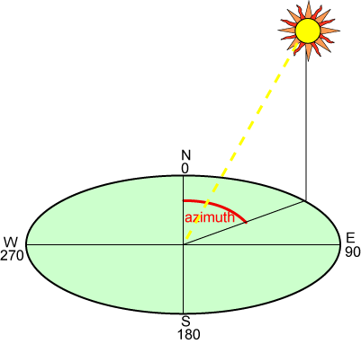
azimuths - the horizontal direction of a celestial point (such as stars) to a terrestrial point (where we are), expressed as an angle.
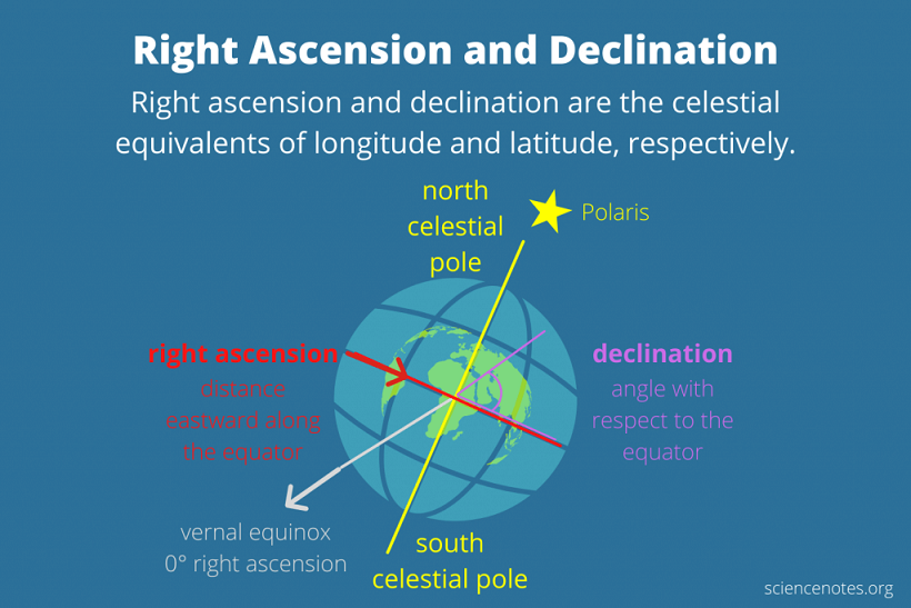
declination - angular distance north or south of the celestial equator. Observed Altitude - the corrected sextant altitude measured by the angular distance of a celestial body above the horizon.
Using celestial navigation helps us determine many things such as our location, compass directions and errors, and even the times of sunrise and sunset. To do this we use an instrument called a sextant. It measured the altitude of any celestial point in the sky (such as the sun or stars) off of the horizon. With the numbers obtained from the sextant, we go into publications like the nautical almanac and sight reduction tables to interpolate series of numbers that give us the information we need. Today we did problems using these books that gave us the gyro compass error. This error tells us what we should steer the ship for the most efficient course line. Celestial navigation is one of the harder math intensive courses on the deck side. Mariners have been navigating using celestial bodies for centuries and the skill will always need to be known by mariners for years to come.
This afternoon and evening I spent working on finishing up my Voyage Plan. After weeks of pulling information from books, tables, and publications as well as numerous mathematical calculations, it is all coming together. I have my report that includes everything a Voyage Plan must have. Ship berthing information, anchorages, estimated times of arrives, way points, aids to navigation, tides at certain times, currents, winds, weather, pilotage information, tug boat information, hazards to navigation, and much more. Along with this magnitude of raw information, I am writing a “narrative” which basically sums up the most relevant of this information and I must present this to my class. With the narrative, I also have the charts I have used to visualize much of my information and plot my courses. All of this work is used to simulate the jobs mates and officers must undergo out in the maritime industry. It might seem like an amplitude of data but it is imperative to safe and efficient navigation.
As you can see, despite Sea Term only having a few days left, work and schedules are plentiful as ever. I thank everyone who has been joining my and my shipmate’s blogs the past couple of weeks. There is much to learn at sea and I hope all of y’all get to experience sailing the oceans just like us. As always, I’m happy to answer any questions, thank you again for joining today’s blog.
Thanks so much, James! You ended Sea Term just the way you began - with an informative, detailed blog delivered on time. I have appreciated your enthusiasm and dedication so much. You have inspired countless students from across the United States and around the world.
On behalf of every student participating in the Follow The Voyage-Share The Experience Program, I wish you good luck as you continue to pursue your degree in Marine Transportation at Massachusetts Maritime Academy.